"Volcanos" WEEK 5

India's has 7 Volcanos but only two are active
Stratovolcano and Mud Volcanoes
The first recorded eruption of the volcano dates back to 1787. Since then, the volcano has erupted more than ten times, with the most recent one being in 2022.[11] After the first recorded eruption in 1787, further eruptions were recorded in 1789, 1795, 1803–04, and 1852. After nearly one and a half century of dormancy, the island had another eruption in 1991 that lasted six months and caused considerable damage.[12][13]
The 1991 eruption was particularly harmful to the island's fauna. A team from the Geological Survey of India visited Barren Island on 8–9 April 1993 to assess the impact of the eruption on the distribution, habit, and abundance of animal species. The report found that the eruption had reduced the number of bird species and their population. The team only observed 6 of the 16 known species of birds on the island. The Pied Imperial Pigeon (Ducula bicolor) was the most abundant among the 6 species observed. In a survey conducted at night, the team spotted one rat species (Rattus rattus) and 51 species of insects from eight orders. The report also noted that the volcano was still emitting gas at the time.[10] There were eruptions in 1994–95 and 2005–07, the latter considered to be linked to the 2004 Indian Ocean earthquake.[12] A lighthouse that was established in 1993 was destroyed by the recent eruptions.[14]
A team from the National Institute of Oceanography spotted the volcano erupting on 23 January 2017. Abhay Mudholkar, the head of the team, said, "The volcano is erupting in small episodes of about five to ten minutes. During the day, only ash clouds were observed. However, after sundown, red lava fountains were spewing from the crater into the atmosphere and hot lava flowed streaming down its slopes."[15][16][17]
Based on argon-argon dating of samples from Barren Island, it is now established that the oldest subaerial lava flows of the volcano are 1.6 million years old and the volcano is located on an oceanic crust which is roughly 106 million years old.[18] All recorded eruptions lie on the low end of the Volcanic Explosivity Index. The 2017 eruption was recorded as a 2 on the index.[10]From Wikipedia, the free encyclopedia
Stratovolcano


Map location of mud volcanos

About 86% of the gas released from these structures is methane, with much less carbon dioxide and nitrogen emitted. Ejected materials are most often a slurry of fine solids suspended in water that may contain a mixture of salts, acids and various hydrocarbons.[citation needed]
Possible mud volcanoes have been identified on Mars.[5]

| Name | Elevation | Location | Last eruption | Type | ||
|---|---|---|---|---|---|---|
| meters | feet | Coordinates | State | |||
| Barren Island | 354 | 1161 | 12.278°N 93.858°E | Andaman Islands | Active since 2021 | Stratovolcano, Active |
| Narcondam | 710 | 2329 | 13.43°N 94.28°E | Andaman Islands | 1681 | Stratovolcano, Dormant |
| Deccan Plateau | 1500 | 4920 | 18.51°N 73.43°E | Central India | 25 Mya(Million years ago) | Caldera |
| Baratang Island | 532 | 1745 | 12.07°N 92.47°E | Andaman Islands | Active since 2003 | Mud volcanoes, Active |
| Dhinodhar Hills | 386 | 1266.4 | 23.45°N 69.34°E | Gujarat | 500 Mya (Million years ago) | Extinct |
| Dhosi Hill | 740 | 2427 | 28.06°N 76.03°E | Haryana | 750 Mya (Million years ago) | Extinct |
| Tosham Hills | 207 | 679 | 28.88°N 75.92°E | Haryana | 732 Mya (Million years ago) | Extinct |
| Loktak Lake | 768 | 2519.04 | 24.45°N 93.47°E | Manipur | 100 Mya (Million years ago) | Supervolcanic caldera, status unknown |

BARREN ISLAND
The first recorded eruption of the volcano dates back to 1787. Since then, the volcano has erupted multiple times.

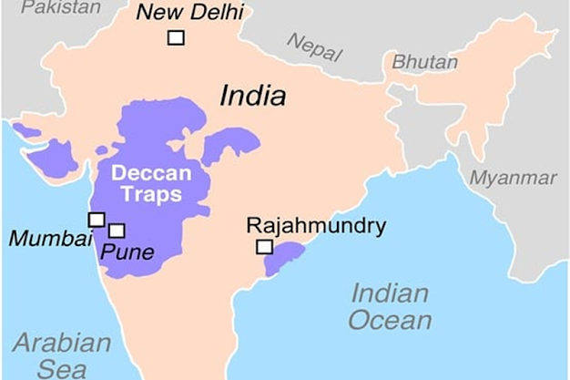
THE DECCAN TRAPS
It is derived from the Scandinavian word for stairs (“trappa”) and refers to the step-like hills forming the landscape of the region.

Dhinodhar Hills of kutch is one of the top and most trekking spots in India.
Dinodhar Hill, an inactive volcano rising to an elevation of 386 meters.

DHOSI HILL
Dhosi Hill is an extinct volcano, standing alone in the
North-West end of the Aravali mountain range with height varying from
about 345 to 470 meters from the surrounding land.
It is part of Aravalli Mountain Range, that belongs
to the Precambrian Malani igneous suite of rocks Dhosi Hill is located
on the borders of the Haryana and Rajasthan.
The Haryana portion lies in Mahendragarh district to the south,
5 kilometres (3.1 mi) from Narnaul on Singhana Road; the Rajasthan portion lies
in Jhunjhunu district to the north.

TOSHAM HILLS
The rocks exposed in and around Tosham hills are part of
subsurface north western spur of Alwar group of Delhi supergroup
of Aravalli Mountain Range, belong to
the Precambrian Malani igneous suite of rocks.
The main Tusham hill is the second largest hill in the range. It
has ancient rock inscriptions and rock paintings, paelo eroded rocky glacial
channels and water cascades, and small hilltop lakes.
It is one of the major biodiversity sites in Haryana.

Tosham Hill (map of Haryana)
What volcano has killed the most people?
Mount Tambora Volcanic eruptions
Human death toll Volcano VEI
How many people have died from volcanoes in total?
https://thinkhazard.org/en/report/115-india/VA
Contacts India National Disaster Management Authority
- National Institute of Disaster Management
India volcanic hazard is classified as low according to the information that is currently available. This means that the selected area is located at less than 50 km from a volcano for which a potentially damaging eruption has been recorded in the past, but over 10,000 years ago. However, the potential for future damaging eruptions cannot be ruled out. Based on this information, the impact of volcanic eruption may be considered in different phases of the project, in particular during project design, implementation and maintenance. Further detailed information should be obtained to adequately account for the level of hazard.
Recommendations
- EARLY WARNING ACTION: Ensure the project can act on volcanic early warnings. This may involve having a plan in place to mobilize in the event of a warning being received. More information
- IMPACT: Consider the effect that potentially lethal and destructive volcanic hazards near to the volcano – ballistic projectiles, lava flows, lahars and pyroclastic flows – could have on the planned project. Lahars can impact areas within valleys as far as 100 km from a volcano. Further information should be gained from local volcanic hazard maps, if available. More information
- REGULATIONS: Check with local authorities for any local regulations concerning volcanic hazards. Ensure that the project conforms to 1) any applicable volcanic hazard land use planning regulations; 2) any existing plans for warning and evacuation; and 3) any national laws, regulations and rules. More information
- TECHNICAL EXPERTISE: Engage a qualified local or international volcanologist to investigate the volcanic hazards in the project area in more depth. Where possible, establish a relationship with the local volcano observatory/agency. More information
- IMPACT FAR FROM HAZARD SOURCE: Consider the effects of volcanic ashfall and gases on the project. These hazards are the most far-reaching of the volcanic hazards and can affect areas hundreds or even thousands of kilometers downwind of volcanoes. More information
https://www.peepultree.world/livehistoryindia/story/religious-places/indias-only-active-volcano
https://roundglasssustain.com/photo-stories/barren-island
https://triumphias.com/blog/indias-active-volcano/


Very interesting information!-what would be the mitigation measures for this hazard? What would you recommend?
ReplyDeletethank you for adding those!
DeleteHi Daniel, it's very cool to learn about the volcanoes in south Asia. I didn't even know that volcanoes erupted there! This is also my first time learning about mud volcanoes, overall very informative.
ReplyDeleteHi there, I really enjoyed the way you talked about the different types of volcanoes and what eruptions continue within the country. The way you organized the sources and details were so great as well.
ReplyDeleteHi, I found it interesting to learn about Mud Volcanos; didn't know about them. During an eruption of a Mud Volcano, do they then cause land slides and or a quick sand effect with all the hot water and mud coming out of them? What if any damage can they do?
ReplyDelete